
Hiking from Cerro Huenes to Cahorros de Monachil
Hiking from Cerro Huenes to Cahorros de MonachilTop Walk in Autumn

TRIP DESCRIPTION
Cahorros de Monachilis a hiking trip close to Granada. We will start in Cumbres Verdes and walk along the Monachil valley with its famous Cahorros. An exciting ecotourism trip in Sierra Nevada National Park, with great views and diverse landscapes, finishing in the spectacular gorge of the Cahorros de Monachil"
Key facts
- Length: 17 km;
- Accumulated height difference: 800 m descent and 300 m ascent;
- Difficulty: Medium;
- Duration: 6-7 hours
- Meeting time: 8:45 am
- Meeting point in Granada: Paseo Enrique Tierno Galvan, Granada (see the map) – Bus line 275 to Cumbres Verdes, Bus stop next to the congress palace. http://siu.ctagr.com/es/horarios_lineas_tabla.php?linea=871
- Finishing point of the hike: Monachil
- Finishing point in Granada: After taking the bus Monachil – Granada – we will arrive at Granada city center
The trip:
We will get off the bus in Cumbres Verdes and start our hike. For the first part of the walk, we will have views down to the city of Granada and its agricultural plain. The path runs through a quite open countryside and sections of forest.
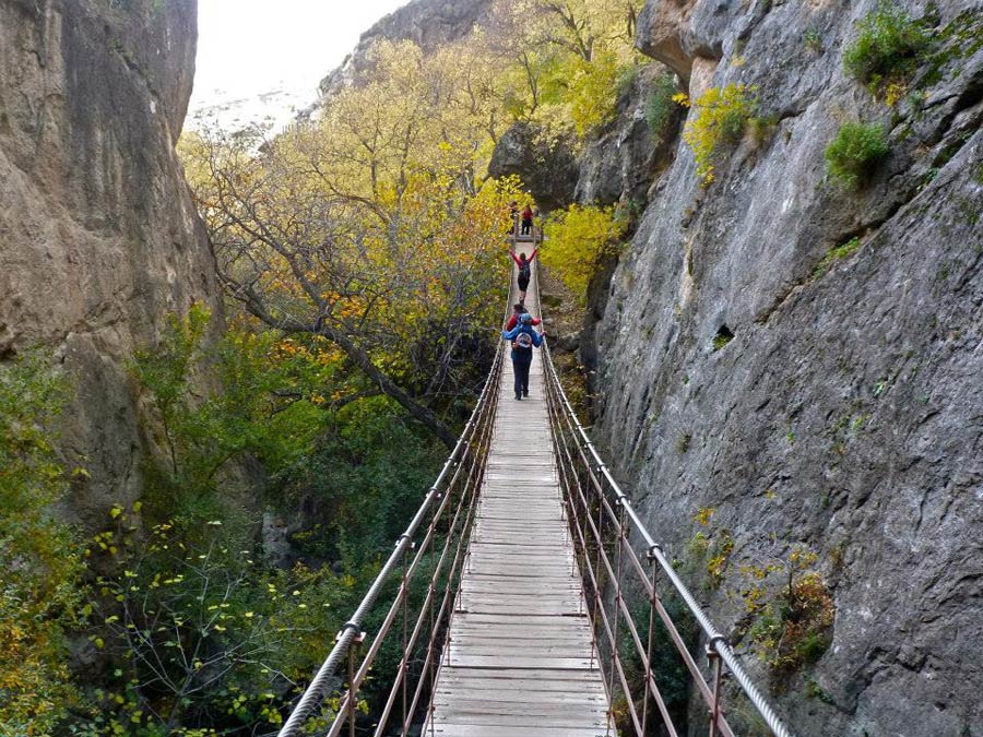
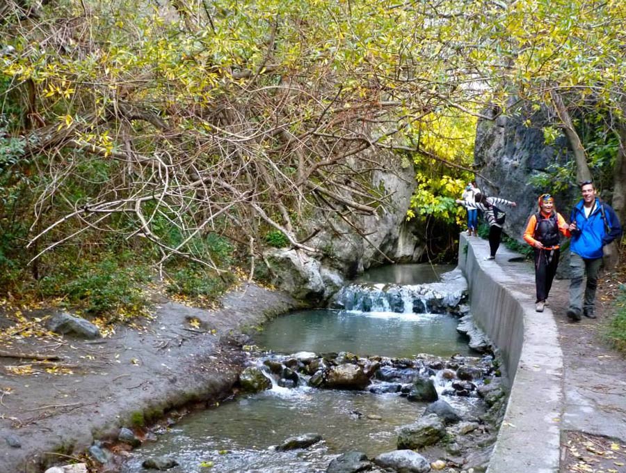
After surrounding the Cerro Huénes hill we will make an important descent to reach the valley of the river Monachil. With its wild flowers, fruit trees, cascading and Tibetan bridges to cross the gorge, the lush Monachil valley is one of the most beautiful areas for walking near Granada. This walk is particularly recommended when the flowers mare out in spring.
The path through the gorge is quite awkward in some sections due to lack of head clearance. Los Cahorros is an enjoyable hike. We will make use of the metal handles set into the rock and will walk always next to the river.
Landscape, heritage, and Natural History:
- Geological origin and evolution of Sierra Nevada and Granada’s plain
- Dolomite and the dolomitic landscape: erosion, gravels, soils, vegetation
- Specific and endemic flora linked to the dolomite and the presence of Magnesium in the soil
- The traditional uses of land
- The formation of the Monachil gorge and its relation with a geological fault.
Equipment recommended:
We recommend carrying 2l of water. Sunglasses, sun cream, protective lip cream, and a hat. Base layer, lightweight fleece, warm fleece or synthetic second layer, windstopper, long trousers, trekking shoes and your personal first aid kit.
Logistics:
Participants should take nuts, dried fruits, and sandwiches for our picnic in the countryside.
Price: €90/pp. 2 people minimum. It includes the guided trip, insurance, and transportation. Ask for group prices
Purchasing Conditions: Excursions must be booked and paid for at least, three days in advance. Participants must arrive at the meeting point on time. The group will wait for participants for five minutes but then leave. In this situation, no money will be reimbursed. All participants should ensure that they know how to get to the meeting point and if you have any questions or doubts, please do not hesitate to contact us.
Price: 90€
Location: Sierra Nevada National ParkDuration: Difficulty: Nivel 2 (REI)
Social Share
-

-

-

-


TRIP DESCRIPTION
Cahorros de Monachilis a hiking trip close to Granada. We will start in Cumbres Verdes and walk along the Monachil valley with its famous Cahorros. An exciting ecotourism trip in Sierra Nevada National Park, with great views and diverse landscapes, finishing in the spectacular gorge of the Cahorros de Monachil"
Key facts
- Length: 17 km;
- Accumulated height difference: 800 m descent and 300 m ascent;
- Difficulty: Medium;
- Duration: 6-7 hours
- Meeting time: 8:45 am
- Meeting point in Granada: Paseo Enrique Tierno Galvan, Granada (see the map) – Bus line 275 to Cumbres Verdes, Bus stop next to the congress palace. http://siu.ctagr.com/es/horarios_lineas_tabla.php?linea=871
- Finishing point of the hike: Monachil
- Finishing point in Granada: After taking the bus Monachil – Granada – we will arrive at Granada city center
The trip:
We will get off the bus in Cumbres Verdes and start our hike. For the first part of the walk, we will have views down to the city of Granada and its agricultural plain. The path runs through a quite open countryside and sections of forest.
After surrounding the Cerro Huénes hill we will make an important descent to reach the valley of the river Monachil. With its wild flowers, fruit trees, cascading and Tibetan bridges to cross the gorge, the lush Monachil valley is one of the most beautiful areas for walking near Granada. This walk is particularly recommended when the flowers mare out in spring.
The path through the gorge is quite awkward in some sections due to lack of head clearance. Los Cahorros is an enjoyable hike. We will make use of the metal handles set into the rock and will walk always next to the river.
Landscape, heritage, and Natural History:
- Geological origin and evolution of Sierra Nevada and Granada’s plain
- Dolomite and the dolomitic landscape: erosion, gravels, soils, vegetation
- Specific and endemic flora linked to the dolomite and the presence of Magnesium in the soil
- The traditional uses of land
- The formation of the Monachil gorge and its relation with a geological fault.
Equipment recommended:
We recommend carrying 2l of water. Sunglasses, sun cream, protective lip cream, and a hat. Base layer, lightweight fleece, warm fleece or synthetic second layer, windstopper, long trousers, trekking shoes and your personal first aid kit.
Logistics:
Participants should take nuts, dried fruits, and sandwiches for our picnic in the countryside.
Price: €90/pp. 2 people minimum. It includes the guided trip, insurance, and transportation. Ask for group prices
Purchasing Conditions: Excursions must be booked and paid for at least, three days in advance. Participants must arrive at the meeting point on time. The group will wait for participants for five minutes but then leave. In this situation, no money will be reimbursed. All participants should ensure that they know how to get to the meeting point and if you have any questions or doubts, please do not hesitate to contact us.


90€
Activity Level Descriptions
REItrips
(1) Relaxed: Adventure travel at its most relaxed pace.
- Activity: 1-3 hours most days
- Distances: walk less than 3 miles most days
- Surfaces: flat terrain
- Elevation change: little to none
- Altitude: less than 3,000 ft
(2) Easy: Great for newcomers to active travel.
- Activity: 2-5 hours most days
- Distances: hike up to 6 miles, cycle 10-30 miles most days
- Surfaces: flat or rolling terrain with some possible steeps
- Elevation change: up to 2,000 ft/day
- Altitude: up to 6,000 ft
(3) Moderate: For outdoor novices and above.
- Activity: 4-6 hours most days
- Distances: hike up to 10 miles most days, cycle 20-40 miles most days
- Surfaces: rolling or mountainous terrain with some steep ascents/descents and uneven trails
- Elevation change: up to 3,000 ft/day
- Altitude: up to 10,000 ft
(4) Vigorous: Recommended for fir travelers with basic skills.
- Activity: 5-8 hours most days
- Distances: hike up to 12 miles most days, cycle 30-50 miles most days
- Surfaces: mountainous, exposed terrain with steep ascents/descents and uneven trails
- Elevation change: up to 4,000 ft/day
- Altitude: up to 14,000 ft
- Experience and a doctor's release may be required
(5) Strenuous: Designed for very fit travelers.
- Activity: 10+ hours/day
- Distances: hike up to 12 miles most days, cycle 50 miles or more miles most days
- Surfaces: remote mountainous, exposed terrain with steep ascents/descents, uneven trails with loose features.
- Elevation change: up to 4,000 ft/day
- Altitude: up to 14,000 ft
- Experience and a doctor's release may be required
Partnership


Contact & Reserve trip
Sierra&Sol | Ecotourism guided hiking and trekking tours in southern Spain
![]()
Placeta de Liñan 5
18010 Granada, España
